Geolocate

Taconite topographic map

Click on the map to display elevation.

About this map

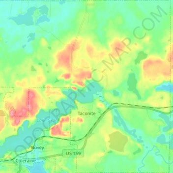
Name: Taconite topographic map, elevation, terrain.

Location: Taconite, Itasca County, Minnesota, United States (47.28241 -93.44804 47.37014 -93.31941)

Average elevation: 1,378 ft

Minimum elevation: 1,280 ft

Maximum elevation: 1,578 ft

Other topographic maps

Click on a map to view its topography, its elevation and its terrain.

Upper Twin Lakes

United States > Minnesota > Itasca County > Rosy

Average elevation: 1,342 ft

Togo

United States > Minnesota > Itasca County

Average elevation: 1,339 ft

Gunny Sack Lake

United States > Minnesota > Itasca County

Average elevation: 1,375 ft

Candy Lake

United States > Minnesota > Itasca County

Average elevation: 1,381 ft

Gear up for your next adventure:

🌎3D Topographic Globes - Raised relief globes for a tactile understanding of geography
🔥Camping Stove - Portable stove for camping and backcountry cooking
🔦Powerful Headlamps - Ultra-bright hands-free lighting for night navigation
💧Water Purification System - Clean water on the trail with reliable purifiers
📡Handheld GPS Device - Reliable handheld GPS for outdoor navigation

As an Amazon Associate, this site earns from qualifying purchases at no extra cost to you.