
Town of Richmond topographic map
Interactive map
Click on the map to display elevation.
About this map
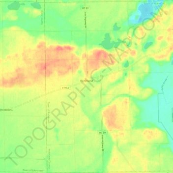
Name: Town of Richmond topographic map, elevation, terrain.
Location: Town of Richmond, Walworth County, Wisconsin, United States (42.66757 -88.77875 42.75589 -88.65912)
Average elevation: 961 ft
Minimum elevation: 866 ft
Maximum elevation: 1,060 ft
Other topographic maps
Click on a map to view its topography, its elevation and its terrain.
Delavan Lake
United States > Wisconsin > Walworth County
Delavan Lake, Town of Delavan, Walworth County, Wisconsin, United States
Average elevation: 965 ft
Town of La Grange
United States > Wisconsin > Walworth County
Town of La Grange, Walworth County, Wisconsin, United States
Average elevation: 935 ft
Abells Corners
United States > Wisconsin > Walworth County
Abells Corners, Town of Lafayette, Walworth County, Wisconsin, 53121, United States
Average elevation: 902 ft
Millard
United States > Wisconsin > Walworth County
Millard, Town of Sugar Creek, Walworth County, Wisconsin, United States
Average elevation: 928 ft
Tibbets
United States > Wisconsin > Walworth County
Tibbets, Town of Sugar Creek, Walworth County, Wisconsin, 53121, United States
Average elevation: 925 ft
Troy Center
United States > Wisconsin > Walworth County
Troy Center, Town of Troy, Walworth County, Wisconsin, United States
Average elevation: 883 ft
Darien
United States > Wisconsin > Walworth County
Darien, Walworth County, Wisconsin, 53114, United States
Average elevation: 942 ft
Como
United States > Wisconsin > Walworth County
Como, Town of Geneva, Walworth County, Wisconsin, United States
Average elevation: 948 ft
Town of Lyons
United States > Wisconsin > Walworth County
Town of Lyons, Walworth County, Wisconsin, United States
Average elevation: 856 ft
Potter Lake
United States > Wisconsin > Walworth County
Potter Lake, Town of East Troy, Walworth County, Wisconsin, United States
Average elevation: 846 ft
Whitewater
United States > Wisconsin > Walworth County
Whitewater, Walworth County, Wisconsin, 53501, United States
Average elevation: 833 ft
East Troy
United States > Wisconsin > Walworth County
East Troy, Walworth County, Wisconsin, 53120, United States
Average elevation: 866 ft
Pell Lake
United States > Wisconsin > Walworth County > Village of Bloomfield
Pell Lake, Village of Bloomfield, Walworth County, Wisconsin, 53157, United States
Average elevation: 863 ft
Geneva Lake
United States > Wisconsin > Walworth County > Lake Geneva
Geneva Lake, Lake Geneva, Town of Linn, Walworth County, Wisconsin, 53125, United States
Average elevation: 945 ft
Williams Bay
United States > Wisconsin > Walworth County
Williams Bay, Walworth County, Wisconsin, 53191, United States
Average elevation: 942 ft
Town of Geneva
United States > Wisconsin > Walworth County
Town of Geneva, Walworth County, Wisconsin, 53147, United States
Average elevation: 971 ft
Lake Como
United States > Wisconsin > Walworth County > Lake Como
Lake Como, Town of Geneva, Walworth County, Wisconsin, 53191, United States
Average elevation: 928 ft
Little Prairie
United States > Wisconsin > Walworth County > Little Prairie
Little Prairie, Town of Troy, Walworth County, Wisconsin, United States
Average elevation: 951 ft
Como Lake
United States > Wisconsin > Walworth County > Como
Como Lake, Como, Town of Geneva, Walworth County, Wisconsin, United States
Average elevation: 948 ft
Town of Sugar Creek
United States > Wisconsin > Walworth County
Town of Sugar Creek, Walworth County, Wisconsin, 53121, United States
Average elevation: 948 ft
Lake Geneva
United States > Wisconsin > Walworth County
Lake Geneva, Walworth County, Wisconsin, United States
Average elevation: 902 ft
Elkhorn
United States > Wisconsin > Walworth County
Elkhorn, Walworth County, Wisconsin, 53121, United States
Average elevation: 981 ft
Delavan
United States > Wisconsin > Walworth County
Delavan, Walworth County, Wisconsin, 53115, United States
Average elevation: 942 ft
Big Foot Beach State Park
United States > Wisconsin > Walworth County > Lake Geneva
Big Foot Beach State Park, Lake Geneva, Walworth County, Wisconsin, United States
Average elevation: 906 ft