
Make a donation
Gear up for your next adventure:
As an Amazon Associate, this site earns from qualifying purchases at no extra cost to you.
Oleftalsperre topographic map
Click on the map to display elevation.
Make a donation
Gear up for your next adventure:
As an Amazon Associate, this site earns from qualifying purchases at no extra cost to you.
About this map
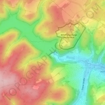
Name: Oleftalsperre topographic map, elevation, terrain.
Average elevation: 1,663 ft
Minimum elevation: 1,322 ft
Maximum elevation: 1,959 ft
Make a donation
Gear up for your next adventure:
As an Amazon Associate, this site earns from qualifying purchases at no extra cost to you.
Other topographic maps
Click on a map to view its topography, its elevation and its terrain.
Weißer Stein
Deutschland > Nordrhein-Westfalen > Kreis Euskirchen > Hellenthal
Mit seinen unterschiedlichen Angaben zufolge 690 m oder 693 m Höhe ist der Weiße Stein nicht nur der höchste Berg von Rureifel und Nordeifel und die höchste Erhebung des Kreises Euskirchen und des linksrheinischen Teils von Nordrhein-Westfalen, sondern auch die zweithöchste Erhebung in Belgien, obgleich…
Average elevation: 2,152 ft