
Make a donation
Gear up for your next adventure:
As an Amazon Associate, this site earns from qualifying purchases at no extra cost to you.
Montana topographic map
Click on the map to display elevation.
Make a donation
Gear up for your next adventure:
As an Amazon Associate, this site earns from qualifying purchases at no extra cost to you.
Montana
The former municipality is located in the Sierre district, above the right bank of the Rhone. It consists of the villages of Montana and Corin, part of the Champzabé, the hamlet of Diogne as well as the resort of Montana-Vermala (located at an elevation of 1,500 m (4,900 ft) and shared between Montana and Randogne).
Make a donation
Gear up for your next adventure:
As an Amazon Associate, this site earns from qualifying purchases at no extra cost to you.
About this map
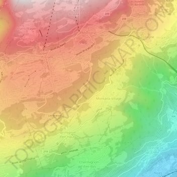
Name: Montana topographic map, elevation, terrain.
Location: Montana, Crans-Montana, Sierre, Wallis, 3960, Switzerland (46.27903 7.47028 46.32009 7.51131)
Average elevation: 4,039 ft
Minimum elevation: 1,690 ft
Maximum elevation: 6,033 ft
Make a donation
Gear up for your next adventure:
As an Amazon Associate, this site earns from qualifying purchases at no extra cost to you.
Other topographic maps
Click on a map to view its topography, its elevation and its terrain.
Les Briesses
Switzerland > Wallis > Sierre > Crans-Montana > Chermignon-d'en-Bas
Average elevation: 3,868 ft
Make a donation
Gear up for your next adventure:
As an Amazon Associate, this site earns from qualifying purchases at no extra cost to you.