
Make a donation
Gear up for your next adventure:
As an Amazon Associate, this site earns from qualifying purchases at no extra cost to you.
Le Domal topographic map
Click on the map to display elevation.
Make a donation
Gear up for your next adventure:
As an Amazon Associate, this site earns from qualifying purchases at no extra cost to you.
About this map
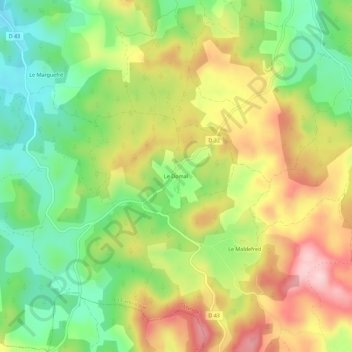
Name: Le Domal topographic map, elevation, terrain.
Average elevation: 2,858 ft
Minimum elevation: 2,500 ft
Maximum elevation: 3,284 ft
Make a donation
Gear up for your next adventure:
As an Amazon Associate, this site earns from qualifying purchases at no extra cost to you.
Other topographic maps
Click on a map to view its topography, its elevation and its terrain.
L'Urugne
France > Occitanie > Lozère > La Canourgue
De 7,2 km de longueur, l'Urugne prend source sur la commune de La Canourgue. Il coule globalement du sud-est vers le nord-ouest et conflue en rive gauche du Lot sur la nouvelle commune de Banassac-Canilhac, à 518 m d'altitude, à moins de 50 m à l'est de l'autoroute française A75 dite la Méridienne. Il…
Average elevation: 2,500 ft