
Thank you for supporting this site ❤️
Make a donation
Make a donation
Gear up for your next adventure:
As an Amazon Associate, this site earns from qualifying purchases at no extra cost to you.
Uruca topographic map
Click on the map to display elevation.
Thank you for supporting this site ❤️
Make a donation
Make a donation
Gear up for your next adventure:
As an Amazon Associate, this site earns from qualifying purchases at no extra cost to you.
Uruca
Uruca has an area of 8.44 km² and an elevation of 1,112 metres.
Thank you for supporting this site ❤️
Make a donation
Make a donation
Gear up for your next adventure:
As an Amazon Associate, this site earns from qualifying purchases at no extra cost to you.
About this map
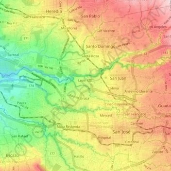
Name: Uruca topographic map, elevation, terrain.
Location: Uruca, Cantón San José, San Jose Province, 10107, Costa Rica (9.94305 -84.18003 9.97203 -84.08531)
Average elevation: 3,648 ft
Minimum elevation: 3,091 ft
Maximum elevation: 4,268 ft
Thank you for supporting this site ❤️
Make a donation
Make a donation
Gear up for your next adventure:
As an Amazon Associate, this site earns from qualifying purchases at no extra cost to you.