
Thank you for supporting this site ❤️
Make a donation
Make a donation
Gear up for your next adventure:
As an Amazon Associate, this site earns from qualifying purchases at no extra cost to you.
Bomdila topographic map
Click on the map to display elevation.
Thank you for supporting this site ❤️
Make a donation
Make a donation
Gear up for your next adventure:
As an Amazon Associate, this site earns from qualifying purchases at no extra cost to you.
About this map
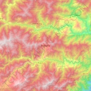
Name: Bomdila topographic map, elevation, terrain.
Location: Bomdila, Bomdila HQ, West Kameng, Arunachal Pradesh, India (27.10445 92.26065 27.42445 92.58065)
Average elevation: 6,670 ft
Minimum elevation: 1,342 ft
Maximum elevation: 10,781 ft
Thank you for supporting this site ❤️
Make a donation
Make a donation
Gear up for your next adventure:
As an Amazon Associate, this site earns from qualifying purchases at no extra cost to you.