Geolocate

Portland topographic map

Click on the map to display elevation.

About this map

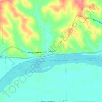
Name: Portland topographic map, elevation, terrain.

Location: Portland, Callaway County, Missouri, 65067, United States (38.69088 -91.73767 38.73088 -91.69767)

Average elevation: 581 ft

Minimum elevation: 486 ft

Maximum elevation: 784 ft

Callaway County trails, hiking, mountain biking, running and outdoor activities

Other topographic maps

Click on a map to view its topography, its elevation and its terrain.

Fulton

United States > Missouri > Callaway County

Average elevation: 807 ft

Mokane

United States > Missouri > Callaway County

Average elevation: 561 ft

Gear up for your next adventure:

🗺️Topographic Maps - Detailed topo maps for hiking, exploring and outdoor navigation
🥩Freeze-Dried Meals - Nutritious and lightweight food for remote expeditions
📷Action Cameras - Rugged cameras to document your journeys across rugged terrain
📦Dry Bags Set - Waterproof storage for electronics and clothes
🪓Survival Multi‑Tool - Versatile tool for camp and trail tasks

As an Amazon Associate, this site earns from qualifying purchases at no extra cost to you.