
Thank you for supporting this site ❤️
Make a donation
Make a donation
Gear up for your next adventure:
As an Amazon Associate, this site earns from qualifying purchases at no extra cost to you.
Fervazzo topographic map
Click on the map to display elevation.
Thank you for supporting this site ❤️
Make a donation
Make a donation
Gear up for your next adventure:
As an Amazon Associate, this site earns from qualifying purchases at no extra cost to you.
About this map
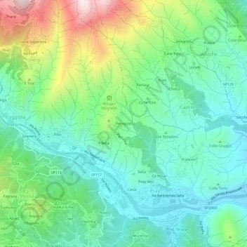
Name: Fervazzo topographic map, elevation, terrain.
Location: Fervazzo, Viera, Coggiola, Biella, Piemonte, 13867, Italia (45.66705 8.18139 45.70705 8.22139)
Average elevation: 1,909 ft
Minimum elevation: 1,283 ft
Maximum elevation: 3,438 ft
Thank you for supporting this site ❤️
Make a donation
Make a donation
Gear up for your next adventure:
As an Amazon Associate, this site earns from qualifying purchases at no extra cost to you.