
Make a donation
Gear up for your next adventure:
As an Amazon Associate, this site earns from qualifying purchases at no extra cost to you.
Waldow topographic map
Click on the map to display elevation.
Make a donation
Gear up for your next adventure:
As an Amazon Associate, this site earns from qualifying purchases at no extra cost to you.
Waldow
Weitere Ortschaften: Białuń (Biallen) | Borzykowo (Voßflöte) | Byczyna (Bütschen) | Cicholas (Schlößchen) | Cieszanowo (Petershof) | Cisy (Alt Julienhof) | Domanice (Charlottenhof) | Gatka (Gadgen) | Gołębsko (Wernershof) | Gomole (Gomellental) | Grądzień (Gründen) | Jeżewsko (Gesifzig) | Kawczyn (Kaffziger Mühle) | Klewno (Klöwstein) | Kołacin (Louisenhof) | Krzeszewo (Buchthal) | Łąkoć (Alt Fließhof) | Łaziska | Lipczyno (Lepzin) | Łodzierz (Hanswalde) | Łosośniki (Lauterbach Fh.) | Malęcino (Mallenzin) | Męciny (Waldower Mühle) | Obrowo (Friederikenfelde) | Olszewiec (Wolschewitz) | Ostrowo (Alt Wustrow Mühle) | Ponikła (Ponickel) | Potok (Pottack) | Potok Młyn (Pottack Mühle) | Pożyczki (Juliushof) | Przemkowo (Antoinettenhof) | Przeradz (Heinrichsdorf) | Stachowo (Stachswalde) | Studnica (Altemühle) | Świeszynko (Neu Schwessin) | Toczeń (Magdalenenhöhe) | Trzebieszyno (Klarashöhe) | Węglewo (Marienhütte) | Zajączkowo (Jägerhaus I) | Znakowo (Schnakenkaten)
Make a donation
Gear up for your next adventure:
As an Amazon Associate, this site earns from qualifying purchases at no extra cost to you.
About this map
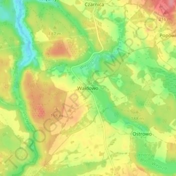
Name: Waldow topographic map, elevation, terrain.
Average elevation: 571 ft
Minimum elevation: 430 ft
Maximum elevation: 719 ft
Make a donation
Gear up for your next adventure:
As an Amazon Associate, this site earns from qualifying purchases at no extra cost to you.
Other topographic maps
Click on a map to view its topography, its elevation and its terrain.