
Thank you for supporting this site ❤️
Make a donation
Make a donation
Gear up for your next adventure:
As an Amazon Associate, this site earns from qualifying purchases at no extra cost to you.
Lieskau topographic map
Click on the map to display elevation.
Thank you for supporting this site ❤️
Make a donation
Make a donation
Gear up for your next adventure:
As an Amazon Associate, this site earns from qualifying purchases at no extra cost to you.
Lieskau
Der Ortskern von Lieskau liegt auf 141 m ü. NHN. Höchste Erhebung ist die Ellahöhe an der westlichen Gemarkungsgrenze mit 163 m ü. NHN. Tiefster Punkt ist bei Seeteich mit 129 m ü. NHN
Thank you for supporting this site ❤️
Make a donation
Make a donation
Gear up for your next adventure:
As an Amazon Associate, this site earns from qualifying purchases at no extra cost to you.
About this map
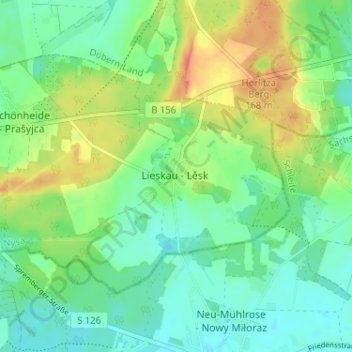
Name: Lieskau topographic map, elevation, terrain.
Average elevation: 466 ft
Minimum elevation: 413 ft
Maximum elevation: 548 ft
Thank you for supporting this site ❤️
Make a donation
Make a donation
Gear up for your next adventure:
As an Amazon Associate, this site earns from qualifying purchases at no extra cost to you.