
Make a donation
Gear up for your next adventure:
As an Amazon Associate, this site earns from qualifying purchases at no extra cost to you.
Jasidih topographic map
Click on the map to display elevation.
Make a donation
Gear up for your next adventure:
As an Amazon Associate, this site earns from qualifying purchases at no extra cost to you.
Jasidih
Jasidih is a Hill Station located at 20°N 89°E / 20°N 89°E / 20; 89. It has an average elevation of 260 metres (853 feet). Its nearby villages are Rohini, Kushmaha, Tabhaghat and others.
Make a donation
Gear up for your next adventure:
As an Amazon Associate, this site earns from qualifying purchases at no extra cost to you.
About this map
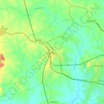
Name: Jasidih topographic map, elevation, terrain.
Location: Jasidih, Deoghar, Jharkhand, 814142, India (24.47425 86.60696 24.55425 86.68696)
Average elevation: 823 ft
Minimum elevation: 735 ft
Maximum elevation: 1,014 ft
Make a donation
Gear up for your next adventure:
As an Amazon Associate, this site earns from qualifying purchases at no extra cost to you.