
Make a donation
Gear up for your next adventure:
As an Amazon Associate, this site earns from qualifying purchases at no extra cost to you.
Starkville topographic map
Click on the map to display elevation.
Make a donation
Gear up for your next adventure:
As an Amazon Associate, this site earns from qualifying purchases at no extra cost to you.
About this map
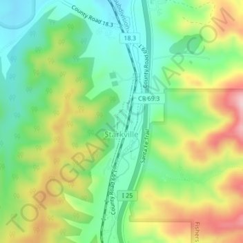
Name: Starkville topographic map, elevation, terrain.
Location: Starkville, Las Animas County, Colorado, United States (37.11133 -104.52559 37.12204 -104.52136)
Average elevation: 6,522 ft
Minimum elevation: 6,247 ft
Maximum elevation: 6,962 ft
Las Animas County trails, hiking, mountain biking, running and outdoor activities
Make a donation
Gear up for your next adventure:
As an Amazon Associate, this site earns from qualifying purchases at no extra cost to you.
Other topographic maps
Click on a map to view its topography, its elevation and its terrain.
Trinidad Lake State Park
United States > Colorado > Las Animas County > Trinidad
Average elevation: 6,450 ft
Make a donation
Gear up for your next adventure:
As an Amazon Associate, this site earns from qualifying purchases at no extra cost to you.
Kim
United States > Colorado > Las Animas County
Kim is located on the plains of southeastern Colorado and the elevation is 5690 ft (1734 m).
Average elevation: 5,692 ft
Make a donation
Gear up for your next adventure:
As an Amazon Associate, this site earns from qualifying purchases at no extra cost to you.