
Make a donation
Gear up for your next adventure:
As an Amazon Associate, this site earns from qualifying purchases at no extra cost to you.
Blandford topographic map
Click on the map to display elevation.
Make a donation
Gear up for your next adventure:
As an Amazon Associate, this site earns from qualifying purchases at no extra cost to you.
Blandford
The town is located near the eastern edge of the Berkshire Hills, above an ancient rift zone where the Connecticut River Valley is downfaulted about 1,000 feet (300 m). The town's elevations range from about 400 feet (120 m) above sea level along streams approaching the Westfield River (a major tributary of the Connecticut) to hilltops as high as 1,700 feet (520 m). Elevations increase to the west with expansive views eastward across the Connecticut River Valley as far as Mount Monadnock in southern New Hampshire. Local relief is as high as 500 feet (150 m) near streams flowing into the Westfield River, but away from these streams the town is characterised by rolling uplands.
Make a donation
Gear up for your next adventure:
As an Amazon Associate, this site earns from qualifying purchases at no extra cost to you.
About this map
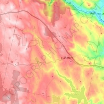
Name: Blandford topographic map, elevation, terrain.
Average elevation: 1,257 ft
Minimum elevation: 335 ft
Maximum elevation: 1,745 ft
Hampden County trails, hiking, mountain biking, running and outdoor activities
Make a donation
Gear up for your next adventure:
As an Amazon Associate, this site earns from qualifying purchases at no extra cost to you.
Other topographic maps
Click on a map to view its topography, its elevation and its terrain.
Mittineague
United States > Massachusetts > Hampden County > West Springfield
Average elevation: 161 ft
Make a donation
Gear up for your next adventure:
As an Amazon Associate, this site earns from qualifying purchases at no extra cost to you.
Make a donation
Gear up for your next adventure:
As an Amazon Associate, this site earns from qualifying purchases at no extra cost to you.
Palmer Green Estates
United States > Massachusetts > Hampden County > Palmer
Average elevation: 459 ft
Make a donation
Gear up for your next adventure:
As an Amazon Associate, this site earns from qualifying purchases at no extra cost to you.
Victory Lake Dam
United States > Massachusetts > Hampden County > Camp Spruce Hill
Average elevation: 1,040 ft
Make a donation
Gear up for your next adventure:
As an Amazon Associate, this site earns from qualifying purchases at no extra cost to you.
Make a donation
Gear up for your next adventure:
As an Amazon Associate, this site earns from qualifying purchases at no extra cost to you.
Skyland
United States > Massachusetts > Hampden County > Tolland > Skyland
Average elevation: 1,211 ft
Make a donation
Gear up for your next adventure:
As an Amazon Associate, this site earns from qualifying purchases at no extra cost to you.