
Make a donation
Gear up for your next adventure:
As an Amazon Associate, this site earns from qualifying purchases at no extra cost to you.
Columbus topographic map
Click on the map to display elevation.
Make a donation
Gear up for your next adventure:
As an Amazon Associate, this site earns from qualifying purchases at no extra cost to you.
Columbus
The confluence of the Scioto and Olentangy rivers is just north-west of Downtown Columbus. Several smaller tributaries course through the Columbus metropolitan area, including Alum Creek, Big Walnut Creek, and Darby Creek. Columbus is considered to have relatively flat topography thanks to a large glacier that covered most of Ohio during the Wisconsin Ice Age. However, there are sizable differences in elevation through the area, with the high point of Franklin County being 1,132 ft (345 m) above sea level near New Albany, and the low point being 670 ft (200 m) where the Scioto River leaves the county near Lockbourne. Numerous ravines near the rivers and creeks also add variety to the landscape. Tributaries to Alum Creek and the Olentangy River cut through shale, while tributaries to the Scioto River cut through limestone.
Make a donation
Gear up for your next adventure:
As an Amazon Associate, this site earns from qualifying purchases at no extra cost to you.
About this map
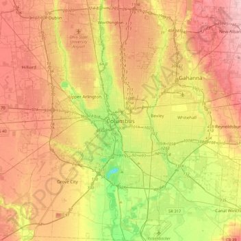
Name: Columbus topographic map, elevation, terrain.
Location: Columbus, Franklin County, Ohio, 43216, United States (39.80226 -83.16071 40.12226 -82.84071)
Average elevation: 837 ft
Minimum elevation: 554 ft
Maximum elevation: 1,093 ft
Franklin County trails, hiking, mountain biking, running and outdoor activities
Make a donation
Gear up for your next adventure:
As an Amazon Associate, this site earns from qualifying purchases at no extra cost to you.
Other topographic maps
Click on a map to view its topography, its elevation and its terrain.
Pickerington Ponds Metro Park
United States > Ohio > Franklin County > Columbus
Average elevation: 791 ft
Edward S. Thomas Nature Preserve
United States > Ohio > Franklin County > Columbus
Average elevation: 902 ft
Make a donation
Gear up for your next adventure:
As an Amazon Associate, this site earns from qualifying purchases at no extra cost to you.