
Make a donation
Gear up for your next adventure:
As an Amazon Associate, this site earns from qualifying purchases at no extra cost to you.
Tamsweg topographic map
Click on the map to display elevation.
Make a donation
Gear up for your next adventure:
As an Amazon Associate, this site earns from qualifying purchases at no extra cost to you.
About this map
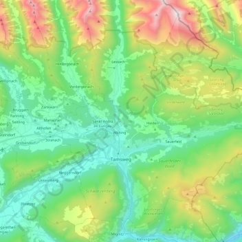
Name: Tamsweg topographic map, elevation, terrain.
Location: Tamsweg, Bezirk Tamsweg, Salzburg, 5580, Austria (47.08162 13.76642 47.21993 13.99613)
Average elevation: 4,754 ft
Minimum elevation: 2,989 ft
Maximum elevation: 8,947 ft
Make a donation
Gear up for your next adventure:
As an Amazon Associate, this site earns from qualifying purchases at no extra cost to you.
Other topographic maps
Click on a map to view its topography, its elevation and its terrain.
Make a donation
Gear up for your next adventure:
As an Amazon Associate, this site earns from qualifying purchases at no extra cost to you.
Oberweißburg
Austria > Salzburg > Bezirk Tamsweg > Sankt Michael im Lungau
Average elevation: 4,508 ft