
Make a donation
Gear up for your next adventure:
As an Amazon Associate, this site earns from qualifying purchases at no extra cost to you.
Alice topographic map
Click on the map to display elevation.
Make a donation
Gear up for your next adventure:
As an Amazon Associate, this site earns from qualifying purchases at no extra cost to you.
Alice
The location was named Lovedale by European missionaries who settled there in 1824.It lies on the southwestern bank of the Tyhume River, west-northwest of East London, at an elevation of 1,720(524m).It was named after John Love of the Glasgow Missionary Society. During the Frontier War it was abandoned and the mission resettled on the west bank of the Tyhume River. On the east bank a fort was built, called Fort Hare, after Major-General John Hare, who was Lieutenant-Governor of the Eastern Cape and acting Governor of the Cape Colony. Later the name of the town was changed to Alice. Alice was the administrative and magisterial capital of the old district of Victoria East. In 1847, it was named Alice by Sir Peregrine Maitland after Princess Alice, the second daughter of Queen Victoria. Municipal status was attained in 1852. The town is now a thriving university town and has received major infrastructure upgrades under the current Mayor Bandile Khethelo.
Make a donation
Gear up for your next adventure:
As an Amazon Associate, this site earns from qualifying purchases at no extra cost to you.
About this map
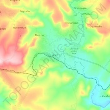
Name: Alice topographic map, elevation, terrain.
Average elevation: 1,923 ft
Minimum elevation: 1,575 ft
Maximum elevation: 2,405 ft
Make a donation
Gear up for your next adventure:
As an Amazon Associate, this site earns from qualifying purchases at no extra cost to you.