
Make a donation
Gear up for your next adventure:
As an Amazon Associate, this site earns from qualifying purchases at no extra cost to you.
Rougham topographic map
Click on the map to display elevation.
Make a donation
Gear up for your next adventure:
As an Amazon Associate, this site earns from qualifying purchases at no extra cost to you.
About this map
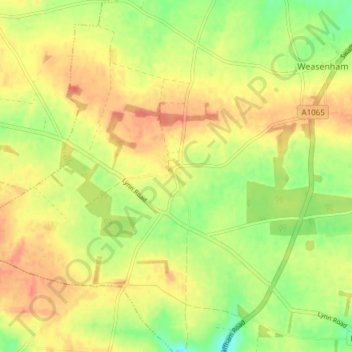
Name: Rougham topographic map, elevation, terrain.
Location: Rougham, Breckland District, Norfolk, England, United Kingdom (52.72751 0.66812 52.77316 0.73209)
Average elevation: 243 ft
Minimum elevation: 157 ft
Maximum elevation: 305 ft
Make a donation
Gear up for your next adventure:
As an Amazon Associate, this site earns from qualifying purchases at no extra cost to you.
Other topographic maps
Click on a map to view its topography, its elevation and its terrain.
Make a donation
Gear up for your next adventure:
As an Amazon Associate, this site earns from qualifying purchases at no extra cost to you.
Make a donation
Gear up for your next adventure:
As an Amazon Associate, this site earns from qualifying purchases at no extra cost to you.
Make a donation
Gear up for your next adventure:
As an Amazon Associate, this site earns from qualifying purchases at no extra cost to you.
Saham Hills
United Kingdom > England > Norfolk > Breckland District > Saham Toney
Average elevation: 200 ft
Make a donation
Gear up for your next adventure:
As an Amazon Associate, this site earns from qualifying purchases at no extra cost to you.
Haverscroft Street
United Kingdom > England > Norfolk > Breckland District > Attleborough
Average elevation: 112 ft
Make a donation
Gear up for your next adventure:
As an Amazon Associate, this site earns from qualifying purchases at no extra cost to you.
Stonebridge
United Kingdom > England > Norfolk > Breckland District > East Wretham
Average elevation: 125 ft
Southburgh
United Kingdom > England > Norfolk > Breckland District > Cranworth > Southburgh
Average elevation: 180 ft
Thorpe Row
United Kingdom > England > Norfolk > Breckland District > Thorpe Row
Average elevation: 226 ft
Make a donation
Gear up for your next adventure:
As an Amazon Associate, this site earns from qualifying purchases at no extra cost to you.
Dam Green
United Kingdom > England > Norfolk > Breckland District > Kenninghall
Average elevation: 151 ft
Moat
United Kingdom > England > Norfolk > Breckland District > Old Buckenham
Average elevation: 167 ft
Make a donation
Gear up for your next adventure:
As an Amazon Associate, this site earns from qualifying purchases at no extra cost to you.