
Thank you for supporting this site ❤️
Make a donation
Make a donation
Gear up for your next adventure:
As an Amazon Associate, this site earns from qualifying purchases at no extra cost to you.
Cemoro Lawang topographic map
Click on the map to display elevation.
Thank you for supporting this site ❤️
Make a donation
Make a donation
Gear up for your next adventure:
As an Amazon Associate, this site earns from qualifying purchases at no extra cost to you.
About this map
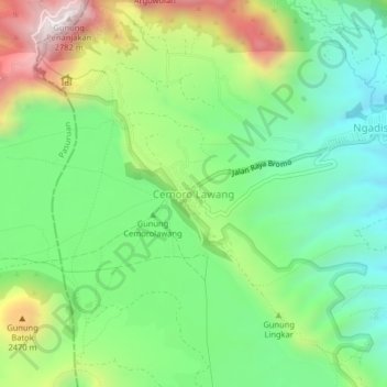
Name: Cemoro Lawang topographic map, elevation, terrain.
Average elevation: 7,123 ft
Minimum elevation: 6,089 ft
Maximum elevation: 9,019 ft
Thank you for supporting this site ❤️
Make a donation
Make a donation
Gear up for your next adventure:
As an Amazon Associate, this site earns from qualifying purchases at no extra cost to you.
Other topographic maps
Click on a map to view its topography, its elevation and its terrain.
Suaka Margasatwa Dataran Tinggi Yang
Indonesia > East Java > Probolinggo > Situbondo
Average elevation: 6,184 ft