
Make a donation
Gear up for your next adventure:
As an Amazon Associate, this site earns from qualifying purchases at no extra cost to you.
Bruisterbosch topographic map
Click on the map to display elevation.
Make a donation
Gear up for your next adventure:
As an Amazon Associate, this site earns from qualifying purchases at no extra cost to you.
Bruisterbosch
Bruisterbosch (Limburgs: Bruusjterbusj) is een buurtschap in de Nederlandse provincie Limburg die behoort bij Sint Geertruid en tegenwoordig onderdeel is van de gemeente Eijsden-Margraten. De buurtschap ligt op ongeveer 168 m hoogte, en had op 1 januari 2007 ongeveer 60 inwoners. In de buurtschap staan 25 hoeven en huizen.
Make a donation
Gear up for your next adventure:
As an Amazon Associate, this site earns from qualifying purchases at no extra cost to you.
About this map
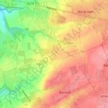
Name: Bruisterbosch topographic map, elevation, terrain.
Average elevation: 512 ft
Minimum elevation: 328 ft
Maximum elevation: 636 ft
Make a donation
Gear up for your next adventure:
As an Amazon Associate, this site earns from qualifying purchases at no extra cost to you.