
Make a donation
Gear up for your next adventure:
As an Amazon Associate, this site earns from qualifying purchases at no extra cost to you.
Iparía topographic map
Click on the map to display elevation.
Make a donation
Gear up for your next adventure:
As an Amazon Associate, this site earns from qualifying purchases at no extra cost to you.
About this map
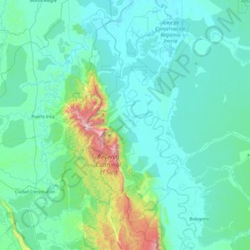
Name: Iparía topographic map, elevation, terrain.
Location: Iparía, Coronel Portillo, Ucayali, Perú (-10.09385 -74.67809 -8.77613 -73.06659)
Average elevation: 1,083 ft
Minimum elevation: 466 ft
Maximum elevation: 7,776 ft
Make a donation
Gear up for your next adventure:
As an Amazon Associate, this site earns from qualifying purchases at no extra cost to you.
Other topographic maps
Click on a map to view its topography, its elevation and its terrain.
Campo Verde
Perú > Ucayali > Campoverde
Campoverde es una localidad peruana ubicada en la región Ucayali, provincia de Coronel Portillo, distrito de Campoverde. Es asimismo capital del distrito de Campoverde. Se encuentra a una altitud de 193 m s. n. m. Tenía una población de 3298 habitantes en 1993. La actividad económica de la localidad está…
Average elevation: 617 ft
Make a donation
Gear up for your next adventure:
As an Amazon Associate, this site earns from qualifying purchases at no extra cost to you.
Make a donation
Gear up for your next adventure:
As an Amazon Associate, this site earns from qualifying purchases at no extra cost to you.