
Make a donation
Gear up for your next adventure:
As an Amazon Associate, this site earns from qualifying purchases at no extra cost to you.
Schorisse topographic map
Click on the map to display elevation.
Make a donation
Gear up for your next adventure:
As an Amazon Associate, this site earns from qualifying purchases at no extra cost to you.
Schorisse
Schorisse ligt in de Vlaamse Ardennen en de hoogte varieert van 32-122 meter. Natuurgebieden zijn het Bos Ter Rijst en het Burreken. Ten westen van Schorisse loopt de Pauwelsbeek in noordelijke richting om uit te monden in de Maarkebeek.
Make a donation
Gear up for your next adventure:
As an Amazon Associate, this site earns from qualifying purchases at no extra cost to you.
About this map
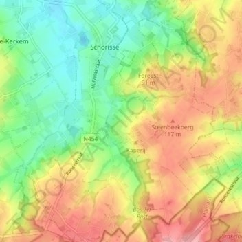
Name: Schorisse topographic map, elevation, terrain.
Average elevation: 249 ft
Minimum elevation: 79 ft
Maximum elevation: 453 ft
Make a donation
Gear up for your next adventure:
As an Amazon Associate, this site earns from qualifying purchases at no extra cost to you.
Other topographic maps
Click on a map to view its topography, its elevation and its terrain.
Make a donation
Gear up for your next adventure:
As an Amazon Associate, this site earns from qualifying purchases at no extra cost to you.