Geolocate

Craignish topographic map

Click on the map to display elevation.

About this map

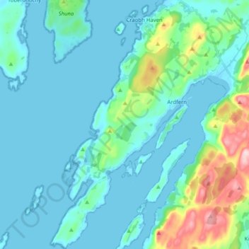
Name: Craignish topographic map, elevation, terrain.

Location: Craignish, Ardfern, Argyll and Bute, Scotland, United Kingdom (56.12995 -5.61468 56.21737 -5.51099)

Average elevation: 118 ft

Minimum elevation: -3 ft

Maximum elevation: 768 ft

Gear up for your next adventure:

🧭Pro Hiking Compasses - High-accuracy liquid-filled compasses for topographic orientation
🚗GPS Dash Cams - Record your scenic drives through mountain passes and canyons
🖼️Topo Map Wall Art - Decorative topographic prints of famous peaks and regions
🩹Survival Bandages - High‑quality bandages for emergencies
🩳Quick‑Dry Hiking Shorts - Comfortable and quick‑dry shorts for summer hiking

As an Amazon Associate, this site earns from qualifying purchases at no extra cost to you.