
Thank you for supporting this site ❤️
Make a donation
Make a donation
Gear up for your next adventure:
As an Amazon Associate, this site earns from qualifying purchases at no extra cost to you.
Turucu topographic map
Click on the map to display elevation.
Thank you for supporting this site ❤️
Make a donation
Make a donation
Gear up for your next adventure:
As an Amazon Associate, this site earns from qualifying purchases at no extra cost to you.
About this map
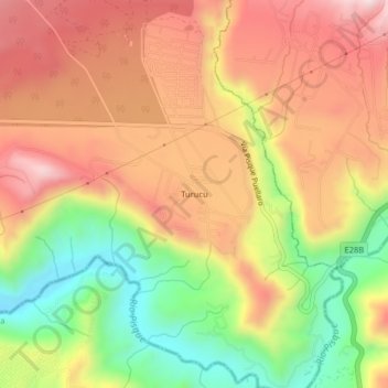
Name: Turucu topographic map, elevation, terrain.
Location: Turucu, Malchingui, Cantón Pedro Moncayo, Pichincha, Ecuador (-0.03654 -78.36832 0.00346 -78.32832)
Average elevation: 7,152 ft
Minimum elevation: 6,191 ft
Maximum elevation: 7,953 ft
Thank you for supporting this site ❤️
Make a donation
Make a donation
Gear up for your next adventure:
As an Amazon Associate, this site earns from qualifying purchases at no extra cost to you.
Other topographic maps
Click on a map to view its topography, its elevation and its terrain.