
Make a donation
Gear up for your next adventure:
As an Amazon Associate, this site earns from qualifying purchases at no extra cost to you.
Medog topographic map
Click on the map to display elevation.
Make a donation
Gear up for your next adventure:
As an Amazon Associate, this site earns from qualifying purchases at no extra cost to you.
Medog
Due to the large elevation difference in the terrain, there are obvious vertical climate changes in the mountains. The annual sunshine hours in Medog County are 1500.7 hours, and the annual average temperature in the valley area is 18°C–22°C. The average temperature in July is 25°C–28°C, and the average temperature in January is 12°C–16°C. There is no frost or occasional light frost throughout the year, and the annual precipitation is 2000-5000 mm. There are 3 species of wild plants under China’s national first-level key protection, 10 species of second-level key protected wild plants, 17 species of first-level national key protected wild animals, and 42 species of second-level key protected wild animals.
Make a donation
Gear up for your next adventure:
As an Amazon Associate, this site earns from qualifying purchases at no extra cost to you.
About this map
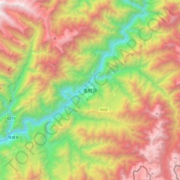
Name: Medog topographic map, elevation, terrain.
Average elevation: 7,779 ft
Minimum elevation: 2,073 ft
Maximum elevation: 15,282 ft
Make a donation
Gear up for your next adventure:
As an Amazon Associate, this site earns from qualifying purchases at no extra cost to you.