Geolocate

Braidwood topographic map

Click on the map to display elevation.

About this map
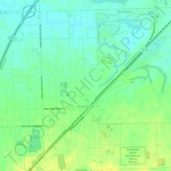
Name: Braidwood topographic map, elevation, terrain.

Location: Braidwood, Will County, Illinois, 60408, United States (41.24865 -88.24653 41.29182 -88.18942)

Average elevation: 574 ft

Minimum elevation: 541 ft

Maximum elevation: 614 ft

Will County trails, hiking, mountain biking, running and outdoor activities

Other topographic maps

Click on a map to view its topography, its elevation and its terrain.

Drummond

United States > Illinois > Will County

Average elevation: 548 ft

Marley

United States > Illinois > Will County

Average elevation: 702 ft

Welco Corners

United States > Illinois > Will County > Bolingbrook

Average elevation: 719 ft

Puddle Pond

United States > Illinois > Will County > Plainfield

Average elevation: 614 ft

Arbury Hills

United States > Illinois > Will County

Average elevation: 709 ft

Gear up for your next adventure:

🥾Hiking Shoes - Durable and comfortable shoes for trail hiking
🏫Relief Map Kits - Hands-on tools for teaching landforms and elevation
🦺Reflective Outdoor Gear - Safety gear for low‑light conditions
📚USA Hiking Guide Books - Top trail guides and map books
🗃️Trail First Aid Kit - Essential kit for outdoor injuries and emergencies

As an Amazon Associate, this site earns from qualifying purchases at no extra cost to you.