
Thank you for supporting this site ❤️
Make a donation
Make a donation
Gear up for your next adventure:
As an Amazon Associate, this site earns from qualifying purchases at no extra cost to you.
Xinpu topographic map
Click on the map to display elevation.
Thank you for supporting this site ❤️
Make a donation
Make a donation
Gear up for your next adventure:
As an Amazon Associate, this site earns from qualifying purchases at no extra cost to you.
About this map
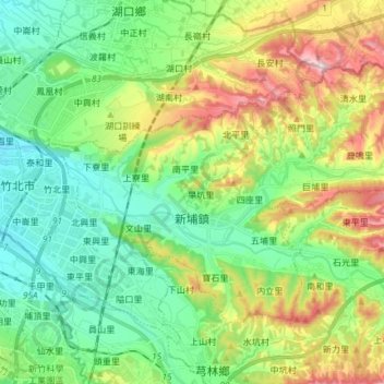
Name: Xinpu topographic map, elevation, terrain.
Location: Xinpu, Hsinchu County, 305, Taiwan (24.79123 121.01361 24.88244 121.16144)
Average elevation: 397 ft
Minimum elevation: 36 ft
Maximum elevation: 1,145 ft
Thank you for supporting this site ❤️
Make a donation
Make a donation
Gear up for your next adventure:
As an Amazon Associate, this site earns from qualifying purchases at no extra cost to you.