
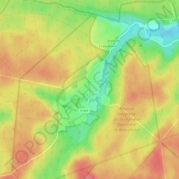
Bresolettes topographic map
Interactive map
Click on the map to display elevation.
About this map
Name: Bresolettes topographic map, elevation, terrain.
Average elevation: 922 ft
Minimum elevation: 781 ft
Maximum elevation: 1,020 ft
Other topographic maps
Click on a map to view its topography, its elevation and its terrain.
Belle Perche
France > Normandie > Orne > Tourouvre au Perche
Belle Perche, Randonnai, Tourouvre au Perche, Mortagne-au-Perche, Orne, Normandie, France métropolitaine, 61190, France
Average elevation: 873 ft
L'Etre Châtel
France > Normandie > Orne > Tourouvre au Perche
L'Etre Châtel, Autheuil, Tourouvre au Perche, Mortagne-au-Perche, Orne, Normandie, France métropolitaine, 61190, France
Average elevation: 738 ft
Lignerolles
France > Normandie > Orne > Tourouvre au Perche
Lignerolles, Tourouvre au Perche, Mortagne-au-Perche, Orne, Normandie, France métropolitaine, 61190, France
Average elevation: 902 ft
Autheuil
France > Normandie > Orne > Tourouvre au Perche
Autheuil, Tourouvre au Perche, Mortagne-au-Perche, Orne, Normandie, France métropolitaine, 61190, France
Average elevation: 728 ft
La Sablonnière
France > Normandie > Orne > Tourouvre au Perche > La Sablonnière
La Sablonnière, Tourouvre, Tourouvre au Perche, Mortagne-au-Perche, Orne, Normandie, France métropolitaine, 61190, France
Average elevation: 843 ft
La Planche
France > Normandie > Orne > Tourouvre au Perche > La Planche
La Planche, Autheuil, Tourouvre au Perche, Mortagne-au-Perche, Orne, Normandie, France métropolitaine, 61190, France
Average elevation: 741 ft
Bubertré
France > Normandie > Orne > Tourouvre au Perche
Bubertré, Tourouvre au Perche, Mortagne-au-Perche, Orne, Normandie, France métropolitaine, 61190, France
Average elevation: 873 ft