
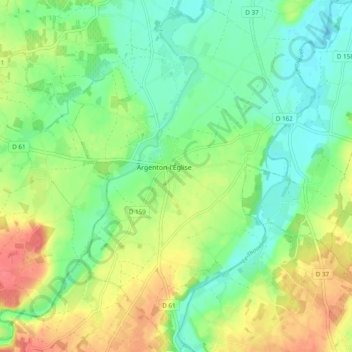
Argenton-l'Église topographic map
Interactive map
Click on the map to display elevation.
About this map
Name: Argenton-l'Église topographic map, elevation, terrain.
Average elevation: 190 ft
Minimum elevation: 118 ft
Maximum elevation: 295 ft
Other topographic maps
Click on a map to view its topography, its elevation and its terrain.
79290
France > Nouvelle-Aquitaine > Deux-Sèvres > Loretz-d'Argenton > Le Petit Ursay
79290, Le Petit Ursay, Bouillé-Loretz, Loretz-d'Argenton, Bressuire, Deux-Sèvres, Nouvelle-Aquitaine, France métropolitaine, France
Average elevation: 180 ft
Jarles
France > Nouvelle-Aquitaine > Deux-Sèvres > Loretz-d'Argenton
Jarles, Bouillé-Loretz, Loretz-d'Argenton, Bressuire, Deux-Sèvres, Nouvelle-Aquitaine, France métropolitaine, 79290, France
Average elevation: 164 ft
Le Brandais
France > Nouvelle-Aquitaine > Deux-Sèvres > Loretz-d'Argenton
Le Brandais, Bouillé-Loretz, Loretz-d'Argenton, Bressuire, Deux-Sèvres, Nouvelle-Aquitaine, France métropolitaine, 79290, France
Average elevation: 220 ft
Loretz-d'Argenton
France > Nouvelle-Aquitaine > Deux-Sèvres > Loretz-d'Argenton
Loretz-d'Argenton, Bressuire, Deux-Sèvres, Nouvelle-Aquitaine, France métropolitaine, 79290, France
Average elevation: 187 ft