
Make a donation
Gear up for your next adventure:
As an Amazon Associate, this site earns from qualifying purchases at no extra cost to you.
Upper Austria topographic map
Click on the map to display elevation.
Make a donation
Gear up for your next adventure:
As an Amazon Associate, this site earns from qualifying purchases at no extra cost to you.
About this map
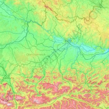
Name: Upper Austria topographic map, elevation, terrain.
Location: Upper Austria, Austria (47.46111 12.74924 48.77256 14.99217)
Average elevation: 2,369 ft
Minimum elevation: 712 ft
Maximum elevation: 9,439 ft
Make a donation
Gear up for your next adventure:
As an Amazon Associate, this site earns from qualifying purchases at no extra cost to you.
Other topographic maps
Click on a map to view its topography, its elevation and its terrain.
Sportgastein
Austria > Salzburg > Bezirk St. Johann im Pongau > Bad Gastein > Naßfeld
Average elevation: 6,089 ft
Hinterglemm
Austria > Salzburg > Bezirk Zell am See > Saalbach-Hinterglemm
Average elevation: 4,567 ft
Make a donation
Gear up for your next adventure:
As an Amazon Associate, this site earns from qualifying purchases at no extra cost to you.