
Make a donation
Gear up for your next adventure:
As an Amazon Associate, this site earns from qualifying purchases at no extra cost to you.
Kirschau topographic map
Click on the map to display elevation.
Make a donation
Gear up for your next adventure:
As an Amazon Associate, this site earns from qualifying purchases at no extra cost to you.
Kirschau
Die evangelische Johanneskirche wurde 1924 eingeweiht. Die auf einer Anhöhe stehende Kuppelkirche im Jugendstil wurde von Arthur Bohlig entworfen. Das oktogonale Bauwerk wird von Rundbogenfenstern erhellt und ist mit Vorbauten an West- und Ostseite versehen. Das Portal zeigt Schmucksäulen und einen Architrav mit den Apostelsymbolen, darüber in einer Nische eine Johannesfigur.
Make a donation
Gear up for your next adventure:
As an Amazon Associate, this site earns from qualifying purchases at no extra cost to you.
About this map
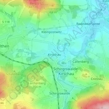
Name: Kirschau topographic map, elevation, terrain.
Average elevation: 984 ft
Minimum elevation: 764 ft
Maximum elevation: 1,604 ft
Make a donation
Gear up for your next adventure:
As an Amazon Associate, this site earns from qualifying purchases at no extra cost to you.
Other topographic maps
Click on a map to view its topography, its elevation and its terrain.
Crostau
Deutschland > Sachsen > Bautzen > Schirgiswalde-Kirschau
Crostau ist ein klassisches Gebirgsdorf. Es erstreckt sich auf einer Höhenlage von 245 m bis 380 m. Umrahmt wird es von mehreren Bergen des Oberlausitzer Berglandes: den Kälbersteinen (487 m), dem Potsberg (448 m), dem Wolfsberg (347 m), dem Horken (307 m) und dem Callenberger Berg (360 m). Verschiedene…
Average elevation: 1,020 ft