Geolocate

Terrytown topographic map

Click on the map to display elevation.

About this map

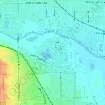
Name: Terrytown topographic map, elevation, terrain.

Location: Terrytown, Scotts Bluff County, Nebraska, United States (41.84100 -103.68598 41.85195 -103.66068)

Average elevation: 3,891 ft

Minimum elevation: 3,862 ft

Maximum elevation: 3,996 ft

Scotts Bluff County trails, hiking, mountain biking, running and outdoor activities

Other topographic maps

Click on a map to view its topography, its elevation and its terrain.

Bald Peak

United States > Nebraska > Scotts Bluff County

Average elevation: 4,242 ft

Gear up for your next adventure:

🎒Outdoor Daypacks - Lightweight backpacks designed for carrying maps and essential gear
🌲Outdoor Survival Books - Best books on survival skills
🪶Camping Sleeping Pad - Comfortable sleeping pad for backpacking
🕶️Glacier Sunglasses - Side shields to protect eyes from high-altitude snow glare
📌Outdoor GPS Map App - Apps and devices for digital topographic navigation

As an Amazon Associate, this site earns from qualifying purchases at no extra cost to you.