
Make a donation
Gear up for your next adventure:
As an Amazon Associate, this site earns from qualifying purchases at no extra cost to you.
Valadares topographic map
Click on the map to display elevation.
Make a donation
Gear up for your next adventure:
As an Amazon Associate, this site earns from qualifying purchases at no extra cost to you.
About this map
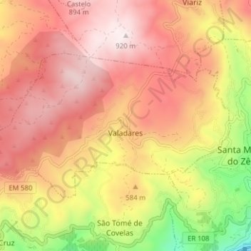
Name: Valadares topographic map, elevation, terrain.
Location: Valadares, Baião, Porto, Portugal (41.13390 -8.01691 41.16096 -7.95431)
Average elevation: 1,870 ft
Minimum elevation: 161 ft
Maximum elevation: 2,989 ft
Make a donation
Gear up for your next adventure:
As an Amazon Associate, this site earns from qualifying purchases at no extra cost to you.
Other topographic maps
Click on a map to view its topography, its elevation and its terrain.
Marão
A Serra do Marão é a sétima maior elevação de Portugal Continental, com 1416 metros de altitude, 681 metros de proeminência topográfica e 59,9 km de isolamento topográfico. Situa-se na região de transição do Douro Litoral para Trás os Montes e Alto Douro.
Average elevation: 3,835 ft
Make a donation
Gear up for your next adventure:
As an Amazon Associate, this site earns from qualifying purchases at no extra cost to you.
Make a donation
Gear up for your next adventure:
As an Amazon Associate, this site earns from qualifying purchases at no extra cost to you.
Make a donation
Gear up for your next adventure:
As an Amazon Associate, this site earns from qualifying purchases at no extra cost to you.
Make a donation
Gear up for your next adventure:
As an Amazon Associate, this site earns from qualifying purchases at no extra cost to you.
Marão
A Serra do Marão é a sétima maior elevação de Portugal Continental, com 1416 metros de altitude, 681 metros de proeminência topográfica e 59,9 km de isolamento topográfico. Situa-se na região de transição do Douro Litoral para Trás os Montes e Alto Douro.
Average elevation: 3,835 ft