
Make a donation
Gear up for your next adventure:
As an Amazon Associate, this site earns from qualifying purchases at no extra cost to you.
Baggio topographic map
Click on the map to display elevation.
Make a donation
Gear up for your next adventure:
As an Amazon Associate, this site earns from qualifying purchases at no extra cost to you.
Baggio
Baggio è una frazione del comune di Pistoia, posta ad una altitudine da 495 a 560 m s.l.m.
Make a donation
Gear up for your next adventure:
As an Amazon Associate, this site earns from qualifying purchases at no extra cost to you.
About this map
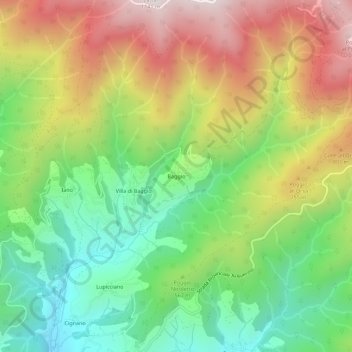
Name: Baggio topographic map, elevation, terrain.
Location: Baggio, Pistoia, Toscana, Italia (43.97009 10.94328 44.01009 10.98328)
Average elevation: 1,877 ft
Minimum elevation: 554 ft
Maximum elevation: 3,612 ft
Make a donation
Gear up for your next adventure:
As an Amazon Associate, this site earns from qualifying purchases at no extra cost to you.
Other topographic maps
Click on a map to view its topography, its elevation and its terrain.