
Make a donation
Gear up for your next adventure:
As an Amazon Associate, this site earns from qualifying purchases at no extra cost to you.
Hopfen am See topographic map
Click on the map to display elevation.
Make a donation
Gear up for your next adventure:
As an Amazon Associate, this site earns from qualifying purchases at no extra cost to you.
Hopfen am See
Der vom Tourismus geprägte Luft- und Kneippkurort liegt am Nordufer des Hopfensees etwa vier Kilometer nordwestlich von Füssen auf einer Höhe von 801 m über NHN. Es gibt zahlreiche Übernachtungsmöglichkeiten in Kurkliniken, Hotels, Ferienwohnungen und Privatunterkünften sowie einen Campingplatz.
Make a donation
Gear up for your next adventure:
As an Amazon Associate, this site earns from qualifying purchases at no extra cost to you.
About this map
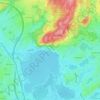
Name: Hopfen am See topographic map, elevation, terrain.
Average elevation: 2,697 ft
Minimum elevation: 2,556 ft
Maximum elevation: 3,064 ft
Make a donation
Gear up for your next adventure:
As an Amazon Associate, this site earns from qualifying purchases at no extra cost to you.
Other topographic maps
Click on a map to view its topography, its elevation and its terrain.
Hopfensee
Deutschland > Bayern > Landkreis Ostallgäu > Füssen > Hopfen am See
Average elevation: 2,621 ft
Alatsee
Deutschland > Bayern > Landkreis Ostallgäu > Füssen
Der Alatsee ist ein meromiktischer See sechs Kilometer westlich von Füssen in Bayern. Er liegt auf 868 Metern Höhe in einer schluchtartigen Senke nur etwa 80 Meter nördlich des Falkensteinkamms mit der Grenze zu Österreich sowie gut 500 Meter südlich des tiefer gelegenen Weißensees. Von diesem ist er…
Average elevation: 2,822 ft