
Thank you for supporting this site ❤️
Make a donation
Make a donation
Gear up for your next adventure:
As an Amazon Associate, this site earns from qualifying purchases at no extra cost to you.
Legarda topographic map
Click on the map to display elevation.
Thank you for supporting this site ❤️
Make a donation
Make a donation
Gear up for your next adventure:
As an Amazon Associate, this site earns from qualifying purchases at no extra cost to you.
About this map
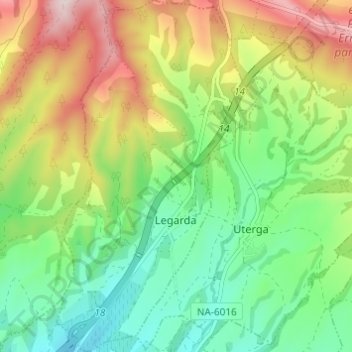
Name: Legarda topographic map, elevation, terrain.
Location: Legarda, Izarbeibar-Novenera / Valdizarbe-Novenera, Spain (42.69463 -1.79335 42.73931 -1.75885)
Average elevation: 1,791 ft
Minimum elevation: 1,302 ft
Maximum elevation: 2,585 ft
Thank you for supporting this site ❤️
Make a donation
Make a donation
Gear up for your next adventure:
As an Amazon Associate, this site earns from qualifying purchases at no extra cost to you.