
Thank you for supporting this site ❤️
Make a donation
Make a donation
Gear up for your next adventure:
As an Amazon Associate, this site earns from qualifying purchases at no extra cost to you.
Santolaya topographic map
Click on the map to display elevation.
Thank you for supporting this site ❤️
Make a donation
Make a donation
Gear up for your next adventure:
As an Amazon Associate, this site earns from qualifying purchases at no extra cost to you.
About this map
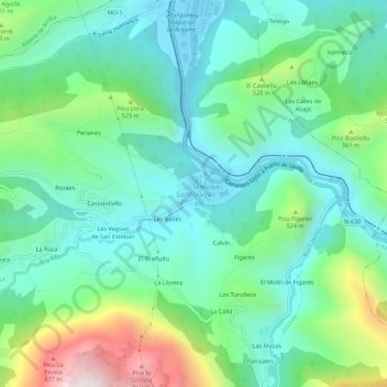
Name: Santolaya topographic map, elevation, terrain.
Location: Santolaya, Morcín, Asturias, 33162, Spain (43.26083 -5.89959 43.30083 -5.85959)
Average elevation: 1,184 ft
Minimum elevation: 410 ft
Maximum elevation: 3,343 ft
Thank you for supporting this site ❤️
Make a donation
Make a donation
Gear up for your next adventure:
As an Amazon Associate, this site earns from qualifying purchases at no extra cost to you.