
Make a donation
Gear up for your next adventure:
As an Amazon Associate, this site earns from qualifying purchases at no extra cost to you.
Pico Cornón topographic map
Click on the map to display elevation.
Make a donation
Gear up for your next adventure:
As an Amazon Associate, this site earns from qualifying purchases at no extra cost to you.
Pico Cornón
El Cornón es la cumbre más elevada de la sierra del Cordel, con una altitud de 2125 metros sobre el nivel del mar. Se encuentra situado entre los municipios de Polaciones y la Hermandad de Campoo de Suso en Cantabria (España).
Make a donation
Gear up for your next adventure:
As an Amazon Associate, this site earns from qualifying purchases at no extra cost to you.
About this map
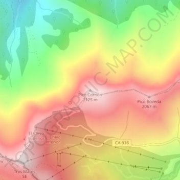
Name: Pico Cornón topographic map, elevation, terrain.
Location: Pico Cornón, Polaciones, Cantabria, 39573, España (43.04848 -4.38952 43.04858 -4.38942)
Average elevation: 5,728 ft
Minimum elevation: 4,229 ft
Maximum elevation: 7,005 ft
Make a donation
Gear up for your next adventure:
As an Amazon Associate, this site earns from qualifying purchases at no extra cost to you.