
Kabul District topographic map
Interactive map
Click on the map to display elevation.
About this map
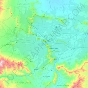
Name: Kabul District topographic map, elevation, terrain.
Location: Kabul District, Kabul Province, Afghanistan (34.40702 68.99655 34.61048 69.36164)
Average elevation: 6,457 ft
Minimum elevation: 5,673 ft
Maximum elevation: 10,482 ft
Other topographic maps
Click on a map to view its topography, its elevation and its terrain.
Kabul
Afghanistan > Kabul Province > Kabul District
Kabul, Kabul District, Kabul Province, 1001, Afghanistan
Average elevation: 6,381 ft
Qarabagh
Afghanistan > Kabul Province > Qarabagh
Qarabagh, Kabul Province, Afghanistan
Average elevation: 5,171 ft
3rd District
Afghanistan > Kabul Province > Kabul
3rd District, Kabul, Kabul Province, 1009, Afghanistan
Average elevation: 6,024 ft