
Make a donation
Gear up for your next adventure:
As an Amazon Associate, this site earns from qualifying purchases at no extra cost to you.
Springfield topographic map
Click on the map to display elevation.
Make a donation
Gear up for your next adventure:
As an Amazon Associate, this site earns from qualifying purchases at no extra cost to you.
About this map
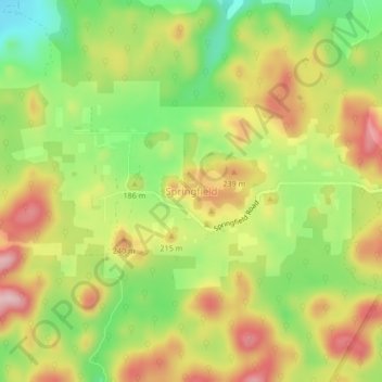
Name: Springfield topographic map, elevation, terrain.
Location: Springfield, Cayo, Belize (17.12555 -88.82529 17.16555 -88.78529)
Average elevation: 581 ft
Minimum elevation: 223 ft
Maximum elevation: 938 ft
Make a donation
Gear up for your next adventure:
As an Amazon Associate, this site earns from qualifying purchases at no extra cost to you.
Other topographic maps
Click on a map to view its topography, its elevation and its terrain.
Belmopan
Belmopan is located in Cayo District at an altitude of 76 metres (249 feet) above sea level. Belmopan was constructed just to the east of the Belize River, 80 km (50 mi) inland from the former capital, the port of Belize City, after that city's near destruction by Hurricane Hattie in 1961. The government was…
Average elevation: 200 ft
Make a donation
Gear up for your next adventure:
As an Amazon Associate, this site earns from qualifying purchases at no extra cost to you.
Belmopan
Belmopan is located in Cayo District at an altitude of 76 metres (249 feet) above sea level. Belmopan was constructed just to the east of the Belize River, 80 km (50 mi) inland from the former capital, the port of Belize City, after that city's near destruction by Hurricane Hattie in 1961. The government was…
Average elevation: 200 ft