
Sidi Mezghiche topographic map
Interactive map
Click on the map to display elevation.
About this map
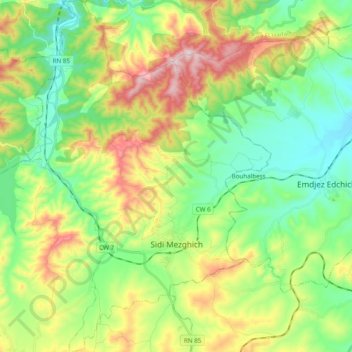
Name: Sidi Mezghiche topographic map, elevation, terrain.
Location: Sidi Mezghiche, Daïra Sidi Mezghiche, Skikda, Algérie (36.63059 6.63672 36.78580 6.77384)
Average elevation: 758 ft
Minimum elevation: 180 ft
Maximum elevation: 1,834 ft
Other topographic maps
Click on a map to view its topography, its elevation and its terrain.
Ain Bouziane
Algérie > Skikda > Daïra Sidi Mezghiche
Ain Bouziane, Daïra Sidi Mezghiche, Skikda, Algérie
Average elevation: 1,355 ft