
Ain Bouziane topographic map
Interactive map
Click on the map to display elevation.
About this map
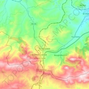
Name: Ain Bouziane topographic map, elevation, terrain.
Location: Ain Bouziane, Daïra Sidi Mezghiche, Skikda, Algérie (36.55242 6.66069 36.65608 6.82972)
Average elevation: 1,355 ft
Minimum elevation: 344 ft
Maximum elevation: 2,871 ft
Other topographic maps
Click on a map to view its topography, its elevation and its terrain.
Sidi Mezghiche
Algérie > Skikda > Daïra Sidi Mezghiche
Sidi Mezghiche, Daïra Sidi Mezghiche, Skikda, Algérie
Average elevation: 758 ft