
Make a donation
Gear up for your next adventure:
As an Amazon Associate, this site earns from qualifying purchases at no extra cost to you.
Darłowo topographic map
Click on the map to display elevation.
Make a donation
Gear up for your next adventure:
As an Amazon Associate, this site earns from qualifying purchases at no extra cost to you.
Darłowo
The elevation of the church is attributed to King Eric. He had to do it to commemorate his pilgrimage to the Holy Sepulchre in Jerusalem. The church was built in the fifteenth century on a plan of a hexagon with the twelve-sided bypass in Scandinavian-style Gothic. This is an exception in the whole Pomerania. Some scholars date back its construction to the years 1450 – 1460, i.e. the period of King Eric's stay in Darłowo (1449–1459). The Church of Saint Gertrude is shown on the map of a Pomeranian cartographer Lubinus, completed in 1618. The earliest mention of the Chapel of St. Gertrude comes from 1497, when Darłowo was hit by the largest-ever flood caused most likely by the tsunami waves called by his contemporaries the Bear Sea. Then, under the hill where the chapel stands, the waves threw ships. The tragic flooding caused the then parish priest, along with the mayor vow that from now on, every year a penance- pleading procession through the streets of Darłowo would take place. The tradition of the procession was revived in 1991. Currently, it takes place in September.
Make a donation
Gear up for your next adventure:
As an Amazon Associate, this site earns from qualifying purchases at no extra cost to you.
About this map
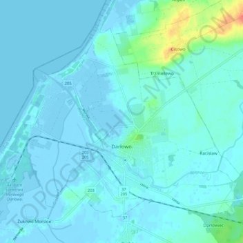
Name: Darłowo topographic map, elevation, terrain.
Location: Darłowo, Sławno County, West Pomeranian Voivodeship, Poland (54.40475 16.35745 54.45272 16.46217)
Average elevation: 13 ft
Minimum elevation: -13 ft
Maximum elevation: 131 ft
Make a donation
Gear up for your next adventure:
As an Amazon Associate, this site earns from qualifying purchases at no extra cost to you.