
Make a donation
Gear up for your next adventure:
As an Amazon Associate, this site earns from qualifying purchases at no extra cost to you.
Vianden topographic map
Click on the map to display elevation.
Make a donation
Gear up for your next adventure:
As an Amazon Associate, this site earns from qualifying purchases at no extra cost to you.
Vianden
Like the city of Luxembourg, Vianden (altitude ca. 200 m) has a temperate climate with warm summers (average day temperature around 24°C, on occasion as high as 35 °C) and chilly winters (daytime average 5 °C but sometimes as low as −15 °C at night). Rainfall is moderate, but on average it rains less than 10 days per month. The prevailing wind is south-westerly. The summer evenings are particularly pleasant, often with temperatures of around 25 °C until 11 pm. Very occasionally there are short periods of drought but the vegetation seldom loses its rich green for very long.
Make a donation
Gear up for your next adventure:
As an Amazon Associate, this site earns from qualifying purchases at no extra cost to you.
About this map
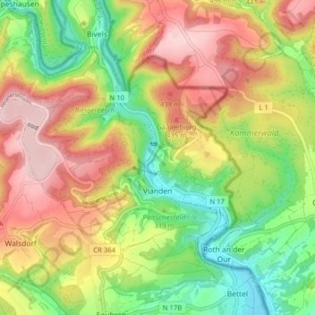
Name: Vianden topographic map, elevation, terrain.
Location: Vianden, Canton Vianden, Luxembourg (49.92283 6.14896 49.95519 6.22733)
Average elevation: 1,115 ft
Minimum elevation: 630 ft
Maximum elevation: 1,660 ft
Make a donation
Gear up for your next adventure:
As an Amazon Associate, this site earns from qualifying purchases at no extra cost to you.
Other topographic maps
Click on a map to view its topography, its elevation and its terrain.