Geolocate

Repentigny topographic map

Click on the map to display elevation.

About this map

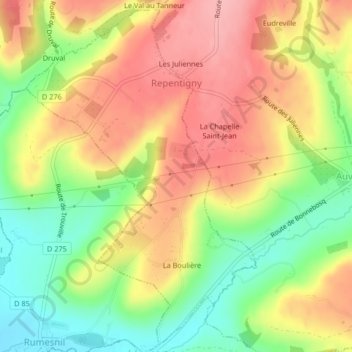
Name: Repentigny topographic map, elevation, terrain.

Location: Repentigny, Lisieux, Calvados, Normandy, Metropolitan France, 14340, France (49.18511 0.02804 49.21093 0.05503)

Average elevation: 292 ft

Minimum elevation: 82 ft

Maximum elevation: 476 ft

Other topographic maps

Click on a map to view its topography, its elevation and its terrain.

Juno Beach

France > Normandy > Calvados > Courseulles-sur-Mer

Average elevation: 13 ft

La Renoullière

France > Normandy > Calvados > Noues de Sienne

Average elevation: 856 ft

Le Domaine

France > Normandy > Calvados > Basseneville

Average elevation: 26 ft

Hasting

France > Normandy > Calvados > Dives-sur-Mer

Average elevation: 105 ft

Les Panniers

France > Normandy > Calvados > Saint-Jouin

Average elevation: 262 ft

Mont Pinçon

France > Normandy > Calvados > Les Monts d'Aunay

Average elevation: 932 ft

Les Manoirs

France > Normandy > Calvados > Glanville > Les Manoirs

Average elevation: 315 ft

Gear up for your next adventure:

😴Insulated Sleeping Pads - Compact and warm pads for high-elevation camping
🖼️Topo Map Wall Art - Decorative topographic prints of famous peaks and regions
🗻Climbing Gear Basics - Essential gear for beginner climbers
🪑Portable Camp Table - Compact table for campsite meals
🥾Men's Hiking Boots - Durable, waterproof footwear for rugged terrain and steep inclines

As an Amazon Associate, this site earns from qualifying purchases at no extra cost to you.