
Make a donation
Gear up for your next adventure:
As an Amazon Associate, this site earns from qualifying purchases at no extra cost to you.
Middleton topographic map
Click on the map to display elevation.
Make a donation
Gear up for your next adventure:
As an Amazon Associate, this site earns from qualifying purchases at no extra cost to you.
Middleton
According to the United States Census Bureau, the town has a total area of 18.5 square miles (47.9 km2), of which 18.1 square miles (46.8 km2) are land and 0.42 square miles (1.1 km2) are water, comprising 2.33% of the town. That water is primarily contained by Sunrise Lake, previously known as the Old Dump Reservoir, near the southern corner of the town. Sunrise Lake drains south toward the Cocheco River in Farmington, while the rest of the town drains eastward toward the Branch River, a tributary of the Salmon Falls River. Jones Brook flows through the center of town and joins the Branch River in the northern part of Milton. The entire town is part of the Piscataqua River watershed. The Moose Mountains, which separate Middleton from Brookfield, have a series of 1,600-to-1,700-foot (490 to 520 m) peaks, including the highest point in Middleton at an elevation of 1,670 feet (510 m) above sea level.
Make a donation
Gear up for your next adventure:
As an Amazon Associate, this site earns from qualifying purchases at no extra cost to you.
About this map
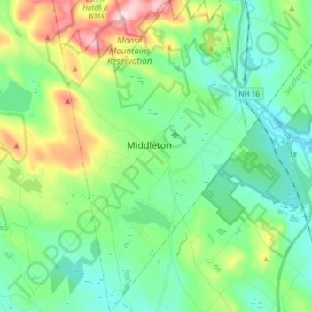
Name: Middleton topographic map, elevation, terrain.
Average elevation: 774 ft
Minimum elevation: 410 ft
Maximum elevation: 1,716 ft
Strafford County trails, hiking, mountain biking, running and outdoor activities
Make a donation
Gear up for your next adventure:
As an Amazon Associate, this site earns from qualifying purchases at no extra cost to you.
Other topographic maps
Click on a map to view its topography, its elevation and its terrain.
Center Strafford
United States > New Hampshire > Strafford County > Strafford
Average elevation: 486 ft
New Durham Corner
United States > New Hampshire > Strafford County > New Durham
Average elevation: 604 ft
Make a donation
Gear up for your next adventure:
As an Amazon Associate, this site earns from qualifying purchases at no extra cost to you.
Make a donation
Gear up for your next adventure:
As an Amazon Associate, this site earns from qualifying purchases at no extra cost to you.