
Make a donation
Gear up for your next adventure:
As an Amazon Associate, this site earns from qualifying purchases at no extra cost to you.
Säntis topographic map
Click on the map to display elevation.
Make a donation
Gear up for your next adventure:
As an Amazon Associate, this site earns from qualifying purchases at no extra cost to you.
Säntis
Le Säntis, culminant à 2 502 m d'altitude, est un sommet du Nord-Est des Alpes suisses. Il est le point culminant du massif de l'Alpstein appartenant aux Préalpes appenzelloises, à cheval entre les cantons d'Appenzell Rhodes-Extérieures, d'Appenzell Rhodes-Intérieures et de Saint-Gall
Make a donation
Gear up for your next adventure:
As an Amazon Associate, this site earns from qualifying purchases at no extra cost to you.
About this map
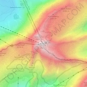
Name: Säntis topographic map, elevation, terrain.
Average elevation: 6,335 ft
Minimum elevation: 4,252 ft
Maximum elevation: 8,136 ft
Make a donation
Gear up for your next adventure:
As an Amazon Associate, this site earns from qualifying purchases at no extra cost to you.
Other topographic maps
Click on a map to view its topography, its elevation and its terrain.