
Thank you for supporting this site ❤️
Make a donation
Make a donation
Gear up for your next adventure:
As an Amazon Associate, this site earns from qualifying purchases at no extra cost to you.
Rarís topographic map
Click on the map to display elevation.
Thank you for supporting this site ❤️
Make a donation
Make a donation
Gear up for your next adventure:
As an Amazon Associate, this site earns from qualifying purchases at no extra cost to you.
About this map
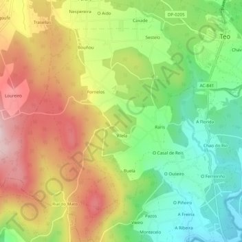
Name: Rarís topographic map, elevation, terrain.
Location: Rarís, Teo, Santiago, A Corogne, Galice, Espagne (42.76531 -8.58700 42.80069 -8.54815)
Average elevation: 591 ft
Minimum elevation: 92 ft
Maximum elevation: 1,168 ft
Thank you for supporting this site ❤️
Make a donation
Make a donation
Gear up for your next adventure:
As an Amazon Associate, this site earns from qualifying purchases at no extra cost to you.