Geolocate

Corfe Castle topographic map

Click on the map to display elevation.

About this map

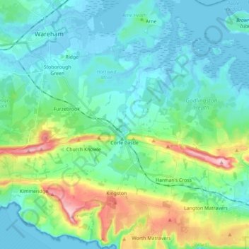
Name: Corfe Castle topographic map, elevation, terrain.

Location: Corfe Castle, Dorset, England, United Kingdom (50.59164 -2.10306 50.70172 -1.96662)

Average elevation: 144 ft

Minimum elevation: -13 ft

Maximum elevation: 663 ft

Other topographic maps

Click on a map to view its topography, its elevation and its terrain.

Fontmell Down

United Kingdom > England > Dorset > Fontmell Magna

Average elevation: 512 ft

Morcombelake

United Kingdom > England > Dorset

Average elevation: 243 ft

Wareham

United Kingdom > England > Dorset

Average elevation: 52 ft

St Ives

United Kingdom > England > Dorset

Average elevation: 79 ft

Muckleford

United Kingdom > England > Dorset > Grimstone

Average elevation: 374 ft

Burning Cliff

United Kingdom > England > Dorset > South Holworth

Average elevation: 210 ft

Ridge

United Kingdom > England > Dorset > Wareham > Ridge

Average elevation: 23 ft

Castletown

United Kingdom > England > Dorset

Average elevation: 59 ft

Mount Ararat

United Kingdom > England > Dorset > Verwood

Average elevation: 197 ft

Chiswell

United Kingdom > England > Dorset

Average elevation: 79 ft

Gear up for your next adventure:

🧴Hand Sanitizer - Keep hands clean while hiking
🧦Merino Wool Socks - Moisture-wicking, blister-preventing socks for long treks
🔌Solar Panel Charger - Charge gear sustainably outdoors
🚑Emergency Bivvies - Heat-reflective sleeping bags for survival situations
🎒Trail Energy Bars - High‑calorie bars for hiking energy

As an Amazon Associate, this site earns from qualifying purchases at no extra cost to you.