
Make a donation
Gear up for your next adventure:
As an Amazon Associate, this site earns from qualifying purchases at no extra cost to you.
Gurupi topographic map
Click on the map to display elevation.
Make a donation
Gear up for your next adventure:
As an Amazon Associate, this site earns from qualifying purchases at no extra cost to you.
Gurupi
Gurupi, Tocantins is a city and a municipality in the Brazilian state of Tocantins. The estimated population was 87,545 inhabitants in 2020, the third-largest in the state, and the total area of the municipality was 1,836 km2. The elevation is around 287 meters in the city.
Make a donation
Gear up for your next adventure:
As an Amazon Associate, this site earns from qualifying purchases at no extra cost to you.
About this map
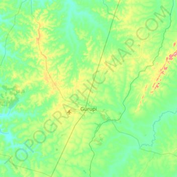
Name: Gurupi topographic map, elevation, terrain.
Average elevation: 919 ft
Minimum elevation: 682 ft
Maximum elevation: 1,834 ft
Make a donation
Gear up for your next adventure:
As an Amazon Associate, this site earns from qualifying purchases at no extra cost to you.
Other topographic maps
Click on a map to view its topography, its elevation and its terrain.